
Just ordered this book by Nicholas Crane (a presenter on the ‘Coast’ TV series) about how Britain’s landscape has been shaped since the last ice age around 12,000 years ago:
http://images-eu.ssl-images-amazon.com/images/I/41NtJNiIivL.AC_US160.jpg
Apparently it deals with human impacts as well as the geographical changes that happened as the ice receded and the seas rose etc. And it sounds like it covers the transition from h/ger to farming societies in some detail, continuing on through the roman period and to the present day. Here’s a snippet from a review in the Guardian:
Around 12,000 years ago Britain was still connected to the mainland of Europe. Glaciers covered much of the north while the south was an arid wind-blasted tundra with grasses, mosses and low shrubs. Around 9700 BC, it became a little warmer, and that’s where Nicholas Crane’s story begins. As he argues in this ambitious, magnificent book, Britain’s destiny was shaped to a surprising degree by the sun and by southerners. It’s a tale of stops and starts – devastating at times, uplifting at others.As temperatures rose, the ice melted, greenhouse gases surged and Britain became greener. Crane, an explorer and geographer, writes evocatively about this changing landscape. “Relieved of its burden, the Earth’s crust sprang slowly upward in the far north,” while the coastline of the south was reconfigured by rising sea levels. River courses altered, trees grew taller and animals such as deer and boars arrived.
With them came the woodland people who, unlike the early hunters, lived in large groups and stayed for a while in one place. They brought tools and made flames with wooden fire drills. Britain’s geology provided them with a vast array of stones, which in turn produced a new sound: “a rhythmic knocking accompanied by high-pitched tinkling” – the sound of the woodland people fashioning them into tools and objects. Meanwhile Doggerland, the area that connected Britain to the continent, was facing the onslaught of rising seas; its inhabitants marched west to escape. Britain has always been a land of migrants.
The first “little ice age” hit around 6700BC. About 500 years later, a huge North American lake broke through its dam and dumped such a huge amount of fresh water into the Atlantic that the Gulf Stream shut down. Temperatures plummeted, trees died, sea water pushed into rivers and Britain’s landscape changed again. Only 200 years later – a geological blink – a tsunami crashed over Doggerland. Britain became an island and isolated. Two thousand years later it was nearly inhabited, and then the climate changed again. The next wave of immigrants arrived – the “house people”, who crossed the channel in their boats and built the first rectangular houses.
They bred animals, grew grains, cleared forests and sculpted the land, leaving traces of human activity on the landscape. Crane describes growing populations, Stonehenge and new materials – copper, iron, bronze. “Technology ages landscapes,” he writes, as ore was hacked out of the land and enormous numbers of trees were used for smelting. By 1000 BC, more of the south of Britain was patterned by rectangular fields – in Dartmeet, for example, a grid covered 3,000 hectares. Then another little ice age hit. Then it got warmer again. And so it goes, up and down. Forts were built, and later lowland settlements, goods arrived by ship, and raw materials left the island.
When the Roman emperor Claudius invaded Britain in AD43, he came, Crane says, with “an army of psychopathic builders” and the British landscape was soon altered beyond recognition. Camps and towns were built along gridded streets. Trees were felled, turf was cut, ditches dug and streams diverted to lace the island with roads. Within four generations, Britain had 24 major cities, palaces, amphitheatres, mosaic flooring and hot baths. It was warm and the soil produced food. And then the climate changed once more.
And a few excerpts via Mark Fisher looking at the arrival of farming through the eyes of the (now extinct) aurochs and trying to piece together what life was like in the (now drowned) ‘Doggerland’:
Amid what he describes as a burgeoning biomass around 9,200BC, while the tundra retreated, horses and reindeer disappeared from southern Britain and were replaced by elk, roe deer, red deer, boar and aurochs. He describes the aurochs as quick, agile and a match for hesitant wolves, their favoured habitat being level, low-lying, fertile and open – “woodland would not have supported the rich grassland they depended upon. Congregating in herds on floodplains and valley floors, they were the biggest beasts in Britain”. It was, however, their preference for valleys and floodplains that put the herds in conflict with humans who used those landscapes for routeways, foraging and hunting missions. They killed aurochs, which were a source of red meat and raw materials like bone and hide, the bone being used to make scrapers for cleaning hides. Crane sees the eventual demise of the aurochs in Britain as being the most conspicuous casualty of the farming onslaught competing for the low-lying, level, fertile land - “Aurochs took to grazing in surviving tracts of marginal wetland, but eventually they lost this last-chance reserve, too. By around 1350BC, Britain’s largest mammal had been driven to extinction”. This congruence with our deliberations was a pleasing surprise: looking at the back of the book I saw that Crane had read many of the same sources of information.
Crane’s evocation of Doggerland, which had at one time been bigger than Britain, was of a low, undulating plain that, before the ice sheet to its north had begun to melt, had been a “cold, arid land of mosses and lichens, sedges, grasses and stunted shrubs that were snow-covered in winter and blasted by frigid, dust-laden winds in summer. Vegetation struggled to reach half a metre in height. Pale clumps of creeping willow, juniper and dwarf birch clung to pockets of soil which had been turned slightly saline by desiccative winds and meagre rainfall” (and see (17) for the extent of ice and tundra). Not much moved across this landscape until around 9700BC when the climate changed, rain fell, perennial wild flowers spread as mats and carpets, and “into this waking land walked some hominids” as an experienced woodland people from more temperate climes (and see (12)) making their passage across Dogglerland to become “newcomers to Britain, with subsistence strategies and tool sets (and presumably beliefs and traditions, too) suited to a warming land scattered with trees — mainly birch and pine — and populated by a diverse flora and fauna”. Thus by the end of the millennium, and with the increasing warmth from the receding ice sheet, elm, oak and lime had returned over Doggerland to grow, along with hazel, in southern England. The birch and pine had moved north into Scotland – “Woodland moved during the course of a human lifetime; on good soils in southern Britain, oak migrated at a rate of 350 to 500 metres a year and pine at 100 to 700 metres a year”
Sea levels had begun to rise from melting ice and the thermal expansion of the oceans as long ago as 18,000 BC (18) attacking Doggerland’s coastlines and flooding its productive wetlands, a low watershed connecting continental uplands between the Rhine and the Elbe, with hills between the Thames and the Ouse – you could walk from the source of the Rhine to the source of the Thames without crossing sea. Crane believes that the Doggerland people probably enjoyed greater returns from their foraging, hunting and fishing than in any area of equivalent size in Britain, but as the number of people in Britain rose, the area of Doggerland continued to contract from the rising sea. By 7000BC, the plains and low hills of Doggerland had shrunk to the point where there was only a narrow connecting bridge, but a tsunami around 6000BC was a violent assault over this low-lying land, clearing woodland, and perhaps hundreds of people were swept away and killed (and see (19)). High tides in the North Sea and Channel broke through the bridge and completed the separation of Britain from the continent. It is speculated that there were remnants of Doggerland that survived as shrinking islands in an ever rising sea, and which may have been waypoints and stepping stones for the first few who ventured a sea journey between the continent and Britain (and see (20,21)) but they too were lost as the sea level rose in all by 70 metres.
[…] the woodland people described by Crane, the new colonists that crossed Doggerland and began to experience the wilderness that they would have found in a warmed England, exploiting the multiplicity of resources that came with a temperate climate and trees (see above). Crane is clear about a key motivating factor for these colonists, because food sources were not distributed evenly, or throughout the year – “The greatest security came with a diverse mix of food and material sources such as those found where two different communities of plants and animals met, or overlapped. These boundary or transition zones between biomes offered the best of two worlds. Examples of these transition zones — or ecotones — included wetlands, the edges of estuaries and coastlines. The value of ecotones soared if they also offered ready access to stone-beds or beaches or riverbeds where workable chert or flint could be collected”
Crane evokes an investment by these people in mapping their new homeland. Thus navigating this wilderness on foot along familiar seasonal cycles was an intense experience, fraught with peril from such as predation or changeable weather that could cause stress and exhaustion. Noting features was a means of accumulating coordinates so that route-finding became a spatial preoccupation and a survival strategy. Crane asserts that paths were expressions of movement through space, and so were the places along the paths where people paused to craft tools from flint, where they butchered an animal, where they rested or slept, looked at a view or meditated. Thus by second passing, a waymark became a source of reassurance, a viewpoint a form of early warning – “Collectively, these various forms of locative paranoia intensified people’s association with places they valued the most. Sleep was a place-maker, too. Lying down with eyes closed for several hours in a night-world of predators demanded faith in a location”. Appreciating or imagining tracts of land as coherent spatial entities was a potent means of controlling space. Crane sees it as coming to an accommodation with the wilderness. Landscapes were mapped in the mind – “A valley, an odd-looking rock, an isolated tree, a parting in the stream were all logged and mentally archived, then more accurately placed with each repassing”. Sounds and smells had their own coordinates in this mapping - “the point where a waterfall became audible was a mappable place, and so was the olfactory perimeter of a pine wood, its proximity mapped by the sweet scent of resin” Crane sees these cognitive or mental maps as a primary tool, the individual remembered locations bonding humans to their landscapes as they were places invested with meaning – “Cognitive maps bound trails and camps, views and waymarks into unitary areas and hafted attachments to homelands. Mind-maps prepared the way for domesticating wilderness”
Crane puts the impact of these pioneer foragers and hunters into perspective when he describes them as wafting through wood and glade like wraiths – “The human imprint on the wilderness was little more than that of the dam-building, river-blocking beavers or heavy-footed elk. Left for a year or two, hearths, stone-scatters and post-holes were rubbed-out by regrowth. Reeds and trees withdrew as areas were fired or coppiced, then advanced again after people moved on. There was a disparity between the recoverable impacts caused by humans, and the wholesale transformation being wrought by earth systems”. It could only be thus because Crane observes that it was still a relatively empty land. Population density lay somewhere between 0.02 and 0.1 per square kilometre, with more people exploiting niches in the south and east than in the north and west, and coasts and estuaries being more populated than interior uplands. Thus Crane reflects that in total, Britain was probably supporting somewhere between 5,000 and 20,000 people (and see (29)). He does a rough calculation of one person for every two million trees based on the assumptions of Britain being a temperate island clothed in 20 billion trees after 5-6 millennia of warming, and supporting a population of 10,000, and concludes that “Europe’s largest island was still a lightly trodden game-park, its land surface faintly etched with foot-tracks and home-bases. The most enduring human landmarks amounted to little more than totemic timber monuments and a scattering of humped middens… So far, the human imprint on Britain had been slight”. But this level of impact would not last in the face of the arrival of agriculture around 4000BC, and nor would the culture of foraging and hunting: this was the “end time”, farming was a culture that “closed histories” (and see (30)). As Crane points out – “Agriculturalists didn’t belong to the wilderness, but took the view that it should be controlled through the breeding and consumption of domesticated animals and cultivated grasses”
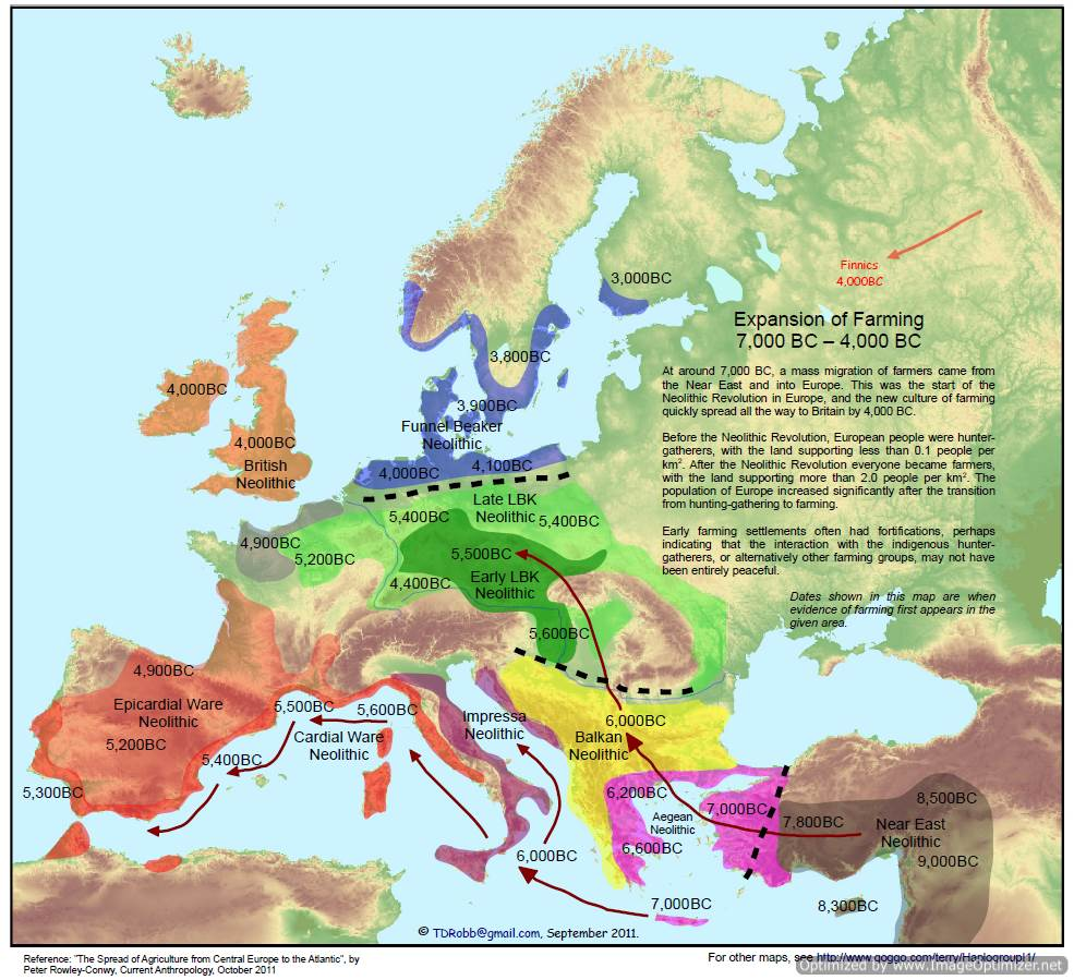
Fisher also links to this pdf presentation of various maps showing how the various cultures shifted around. Surprise surprise, things went mental when they started farming.
Which makes sense when compared to the population growth it unleashed, coupled with what we know about the expansionist, militarist nature of farming societies:
36,000 BC – 26,000 BC: 3,000 to 30,000 people, with 1/3rd in Franco-Cantabrian region; Neanderthal population is 1,000 to 10,000.
26,000 BC – 23,000 BC: 3,000 to 30,000 people, with 1/3rd in Franco-Cantabrian region; Neanderthals extinct by 26,000 BC.
23,000 BC – 17,500 BC: 3,000 to 30,000 people, with 1/3rd in Franco-Cantabrian region;
17,500 BC – 14,000 BC: 5,000 to 50,000 people, with 2/3rd in Franco-Cantabrian region;
14,000 BC – 12,000 BC: 20,000 to 200,000 people, with 2/3rd in Franco-Cantabrian region
[…]
10,000 BC: 200,000 people.
7,000 BC: 400,000 people.
4,000 BC: 2 million people.
2,000 BC: 5 million people.
1,000 BC: 10 million people.
200 BC: 27 million people.
200 AD: 36 million people.
500 AD: 27 million people.
1,000 AD: 38 million people.
1,500 AD: 80 million people.
1,800 AD: 180 million people.
2,000 AD: 750 million people.
It would be interesting to find out what kind of conflict there was between the farming and h/ger societies beyond simply noting that ‘Early farming settlements often had fortifications, perhaps indicating that the interaction with the indigenous hunter-gatherers, or alternatively other farming groups, may not have been entirely peaceful’. I used to assume it would have been the same as the conquest of the Americas, but the timescale seems much longer and I’ve read various bits suggesting that the two subsistence strategies lived side by side for long periods of time, often with the farmers occupying the lowlands and river valleys and the h/gers enduring in the highlands and wooded regions. See this old post of mine:
Anyway I’ll report back if I find any nice juicy bits 
cheers,
Ian

